Novidades

FUI de FÉRIAS com um FURACÃO

VEP

Membro
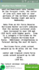
Desta vez não tenho boas notícias infelizmente... O Irma já é um categoria 4 com ventos de 215 km/h e rajadas superiores... A força do Irma já se sente a 220 km desde o seu olho...

Quem for ao site NOAA pode verificar no mapa que ainda está com categoria 3 mas que será em breve actualizado. Já reparei que há um atraso entre a emissão dos relatórios e a actualização do mapa. Supostamente os relatórios são emitidos por aviões da força aérea que sobrevoam o furacão e emitem relatórios na hora... O site é actualizado quando há consenso na alteração de dados interactivos como mapas... Só para não fazerem asneira antes do tempo, só pode...

Vep

PS - editado depois de @rum ter alertado para a gaffe que cometi a confundir RD com Domínica...
 

Anexos

Última edição:

rum

Membro Conhecido
Se não vi mal havia um tropical storm watch para a Dominica não é para a República Dominicana. Da Republica ainda está longe para lançar algum aviso... mas vai ser lançado.
 
  • Gostar
Reações: VEP

rum

Membro Conhecido
Categoria 4. Oficialmente continua a a não haver nem avisos nem alertas para a República Dominicana. Parece-me vai agitar um bom bocado as Bahamas e vai entrar com estrondo na Florida. Quanto às restantes ilhas... é acompanhar.
 

jcmxxx

Membro
...HISPANIOLA...

Hurricane Irma is forecast to approach the area of Hispaniola
early on Thursday.

An upper level inverted trough extends from Hispaniola toward
Costa Rica. Convective precipitation: widely scattered moderate to
isolated has been moving from the western parts of the island into
the Windward Passage.

The GFS MODEL forecast for 250 mb shows that day one will consist
of SE wind flow across the area, with a cyclonic circulation
center that will move toward Jamaica. Day two will consist of
anticyclonic, and easterly, wind flow for much of the time. NE
wind flow will move across the area, replacing the anticyclonic
wind flow, around the middle of day two. The NE wind flow will be
associated with a second cyclonic circulation center that will be
approaching NE Hispaniola from the east, with Hurricane Irma. The
GFS MODEL forecast for 500 mb shows that day one will consist of E
wind flow, becoming NE by the end of the day. Day two will consist
of more NE wind flow, that is associated with the Hurricane Irma
cyclonic circulation center. The GFS MODEL forecast for 700 mb
shows that day one will consist of anticyclonic wind flow. Day two
will consist of NE and cyclonic wind flow, with the Hurricane
Irma cyclonic circulation center, that is forecast to be on the
Atlantic Ocean side of Hispaniola.
 

diogoa21

Membro Novo
...HISPANIOLA...

Hurricane Irma is forecast to approach the area of Hispaniola
early on Thursday.

An upper level inverted trough extends from Hispaniola toward
Costa Rica. Convective precipitation: widely scattered moderate to
isolated has been moving from the western parts of the island into
the Windward Passage.

The GFS MODEL forecast for 250 mb shows that day one will consist
of SE wind flow across the area, with a cyclonic circulation
center that will move toward Jamaica. Day two will consist of
anticyclonic, and easterly, wind flow for much of the time. NE
wind flow will move across the area, replacing the anticyclonic
wind flow, around the middle of day two. The NE wind flow will be
associated with a second cyclonic circulation center that will be
approaching NE Hispaniola from the east, with Hurricane Irma. The
GFS MODEL forecast for 500 mb shows that day one will consist of E
wind flow, becoming NE by the end of the day. Day two will consist
of more NE wind flow, that is associated with the Hurricane Irma
cyclonic circulation center. The GFS MODEL forecast for 700 mb
shows that day one will consist of anticyclonic wind flow. Day two
will consist of NE and cyclonic wind flow, with the Hurricane
Irma cyclonic circulation center, that is forecast to be on the
Atlantic Ocean side of Hispaniola.
-

Resumindo...
 

jcmxxx

Membro
Resumindo, quem lá estiver que fique sossegado que acaba por passar, dura 1 ou 3 dias. Pior vão estar quem lá mora. De qualquer forma prevê-se que o pior estará destinado para a Florida, mas aguardemos. Duvido é que durante 1 / 2 dias haja voos em Punta Cana.
Este sempre foi o meu "terror" de ir para aquelas bandas, ja apanhei um em 1996 mas foi fraquinho, e como nao havia net nem telemóveis nem soube quase de nada, hoje já sofremos por antecipação.
 

diogoa21

Membro Novo
Resumindo, quem lá estiver que fique sossegado que acaba por passar, dura 1 ou 3 dias. Pior vão estar quem lá mora. De qualquer forma prevê-se que o pior estará destinado para a Florida, mas aguardemos. Duvido é que durante 1 / 2 dias haja voos em Punta Cana.
Este sempre foi o meu "terror" de ir para aquelas bandas, ja apanhei um em 1996 mas foi fraquinho, e como nao havia net nem telemóveis nem soube quase de nada, hoje já sofremos por antecipação.

Viajo hoje e o voo não foi cancelado
 

Hello Tomorrow

Membro Conhecido
Li agora no twitter do Michael Ventrice e ele diz que o Irma está próximo de passar a categoria 5, e que vai devastar por completo as Antilhas!!!!

Mesmo que não passe directamente pela República Dominicana, de certeza que vai estragar as férias a muita gente. Devem apanham com ventos, mar revolto, o sol pode nem aparecer!!! Enfim, tudo o que ninguém quer numa semana que supostamente seria de muito sol e praia... :(

"Major Hurricane Irma is a monstrous high end Category 4 Hurricane w/sustained winds of 150mph, min pressure of 937mb; Just 7mph from Cat-5."

"Unbelievable satellite appearance of Major Hurricane Irma My thoughts and prayers are sent to the Antilles as this will be devastating."


Espero estar enganado.
 
Última edição:

rum

Membro Conhecido
Sim, a tendência é para fortalecer e ganhou muita força esta noite... está a apanhar águas cada vez mais quentes. Vai crescer até encontrar terra... parece-me que vai fazer estragos nas Bahamas e fazer-se notar na Florida... pelo caminho até lá vai agitar um bom bocado as Antilhas e Porto Rico, a Hispaniola também será um dos alvos.
 

Regis

Membro
Resumindo, quem lá estiver que fique sossegado que acaba por passar, dura 1 ou 3 dias. Pior vão estar quem lá mora. De qualquer forma prevê-se que o pior estará destinado para a Florida, mas aguardemos. Duvido é que durante 1 / 2 dias haja voos em Punta Cana.
Este sempre foi o meu "terror" de ir para aquelas bandas, ja apanhei um em 1996 mas foi fraquinho, e como nao havia net nem telemóveis nem soube quase de nada, hoje já sofremos por antecipação.
É mesmo, ainda não tinha saído de Madrid no dia 31 e já a minha mãe me ligava a dizer que vinha um furacão para estes lados. Depois fui acompanhando a situação pela net o_Oo_Oo_Oo_Oo_O
 

Hello Tomorrow

Membro Conhecido
Possíveis rotas/categorias para os próximos 10 dias:

PS: Ultima hora, Irma passou a Categoria 5!!!! This is a very dangerous storm! Dizem os especialistas!!

Republica Dominicana já em alerta:

WATCHES AND WARNINGS
--------------------
CHANGES WITH THIS ADVISORY:

The government of the Dominican Republic has issued a Hurricane
Watch from Cabo Engano to the northern border with Haiti and a
Tropical Storm Watch from south of Cabo Engao to Isla Saona.


DI9IZMkVAAE1m7a.jpg


DI9ItJnXcAAkXyL.jpg
 
Última edição:
Top